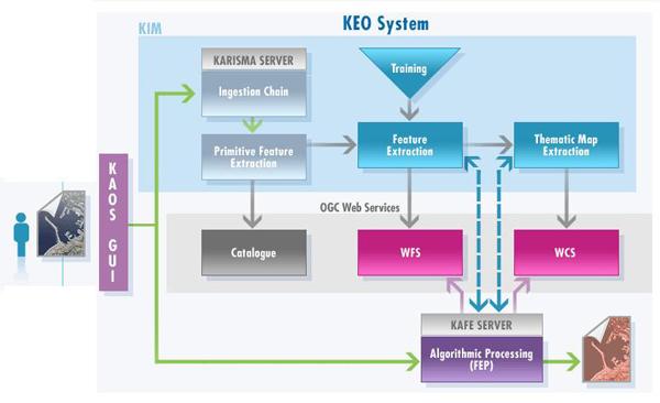
Earth Observation (EO) images can contribute in a number of human activities, from the understanding of global phenomena to decision-making processes. EO images are representation of sensor signals in forms acceptable by human perception. Experts in EO sensing and in destination domains (e.g.: agriculture, meteorology, forestry, urbanism, …) join their knowledge and, interacting at semantic level, extract information from the relevant images (those acquired in the area and period of interest), by visual inspection or applying specific algorithms. This process permits to extract the few kilobytes of user interest from gigabytes of data. However it is complex, lengthy, human intensive and expensive. Therefore it cannot be systematically applied, thus limiting the availability of useful information in support to researchers, service providers and institutions active in non-EO domains. This lack of information flow might make processes or decisions more expensive or even impossible and leave relevant phenomena undetected or discovered too late. Nowadays the situation is getting worse, since larger and larger quantities of higher and higher resolution EO images are acquired from an increasing variety of sensors and stored in archives reaching or surpassing the petabyte size, while emerging big applications (e.g.: change detection, global monitoring, disaster management support, etc.) demand more and more information.In future more automated, direct and human centered methods should be provided for the information extraction process, which should rely on "intelligent" (knowledge-based and learning) and easy to use (semantic driven interactions) programming environments. "Automated" is a consequence of the data size. "Human centred" brings the focus on systems that could be managed also by non-EO experts via simple (semantic) interactions (like those between human beings).The main types of methods available for automated extraction of information from images are: Feature extraction algorithms Probabilistic Information Mining The first type includes methods that are specific for each feature (analysing pixels and looking for a predefined pattern) and therefore more robust and precise. The second type is more generic and based on a probabilistic approach (therefore less precise). t is based on extracting and storing basic characteristics of image pixels and areas, which are then selected (one or more and weighted) by users as representative of the searched feature. It has the following advantages: No need to re-scan the entire image set when searching for new features (if compatible with ingestion parameters) The selected feature can be closer to user expectations and perception(the same feature can have different meanings to different users: e.g. a forest for an environmentalist, a forest guard, a geologist, a urban planner, …) The system can be implemented to learn from experts' knowledge KEO Project (Knowledge-centred Earth Observation) As a step towards the above vision for a system compatible with ESA environment, the KEO project aims at implementing and validating a modular and scalable Component-based Processing Environment which permits to: Ease the access to EO data and relevant information extracted from them Provide a large set of tools for EO data processing (bridging the gap between Data and Information) Expand the use of EO data by supporting and automating the identification and extraction of information relevant for users Encourage the use of a common scientific cooperative environment The KEO system permits users to interactively extract relevant features and information from EO data, either through a generic probabilistic technique or by means of specific processing algorithms, and to provide outputs, i.e. valuable information extracted from data, in easily accessible formats.KEO exploits knowledge (interactively learned or stored into software components or services) via semantic interfaces. In the ground segment environment, it is integrated, as shown in the figure below, to archives (to receive products), catalogues (to provide image information content) and to the SSE (Service Support Environment, to provide services). KEO project has been developed in several steps and phases by GTD and several other European partners for ESA (European Space Agency). KEO system prototype deployed at ESRIN and based on the following functionalities: Create & semantically identify internal / external Processing Components Create Processing Components from KIM training (also interactive use) Graphically chain Processing Components into more complex Processing Chains Store output into Web Servers (WFS, WMS, WCS) Create and publish Web Services (from Processing Chains or output)